The most iconic mountain in the Alps, the 4478m Matterhorn is part of the huge Monte Rosa massif which straddles the border between Switzerland and Italy. The only way from one side of the massif to the other is by foot or by air, there are no bridges or tunnels for the supporter's car. Driving from one side to the other takes several hours: Cervina (Italy) to Zermatt (Switzerland) - only 13km apart as the crow flies - are 232km and 3.5 hours distant by road via the Grand St Bernard pass. This turnpoint will likely be the most challenging of the 2009 Red Bull X-Alps, both physically and logistically. It could make or break several athletes in the race.
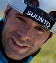
Back in Decemeber I visited Zermatt to chat to the local pilots about the flying options on the north side, two weekends ago I visited Gressoney-la-Trinite (Italy) during a freeride ski weekend to check out the southern options. The photo, taken by Sébastien Jossi, shows me looking over the Val de Gressoney from the Rothorn pass. The summit below the sun is the Testa Grigia (3315m) on the ridge between Gressoney-la-Trinite and St Jacques.
The obvious route from the Marmolada takes us in an almost straight line to Domodossola in Northern Italy and then onwards west to Macugnaga. But here the obvious route abruptly ends. On a direct line to the Matterhorn lies the Dufourspitze, at 4633m the highest mountain in Switzerland. Its imposing 2700m vertical East face, one of the very largest faces in the Alps blocks our way. Few options present themselves, none of them good.
 Heading just north of the summit, the lowest pass to Zermatt is at 3400m. High mountain glaciated terrain, and the far side is flat enough that if you were to fly from the col it's unclear if you would out-glide the huge Gorner glacier (shown in the photo on the right taken by Zacharie Grossen) to reach a safe landing in Zermatt (1600m). Assuming you do make it to Zermatt, then you find yourself trapped by 4000m summits in all directions and it's another 1800m vertical ascent through inhospitable glaciated terrain to a col to regain the south face of the Monte Rosa massif. Those without mountaineering experience need not apply.
The terrain to the south could hardly be less favourable to X-Alps competitors. A series of 3000m ridges run north-south with deep valleys in between. The cols are high and the valleys are low: to get from Macugnaga to Cervina involves four successive ascents of 1500m, 1600m, 1000m and 1200m respectively -- that's over 5000m of vertical just to make about 25km of forward progress. Walkers following the classic Tour of Monte Rosa will take four days to do this, we'll want to do it in much less. Logistically it's a nightmare: the supporter has a multihour drive between each trailhead at the top of each valley.
Other possibilities include walking round the south side of the massif (about 200km from Domodossola to Cervina) or making an early radical route choice and crossing into the Swiss Vallais and approaching the Matterhorn from the north, a very long way round and risking disqualification if you infringe the Sion or Zermatt airspace.
So much will depend on the weather here and the final position and radius of the turnpoint (the race organisation haven't defined it yet). If flying conditions are good it's possible that we'll be able to fly from Domodossola to the Matterhorn in one day (it's only about 50km by air) but cloudbase will have to be very high for us to surf the south face of the Monte Rosa and safely pass the numerous cols at 2800m. The only flights in XContest's amazing Skyways map are top-to-bottoms from the summit of the Breithorn (4164m). If conditions are mediocre then maybe we'll be able to skip some of the ascent by flying from the cols and landing halfway up the slope on the far side. Should the weather be bad enough to keep everyone grounded then it's not inconceivable that the more-flying-less-walking competitors, having flown much of the way from the Marmolada, will be slowed by the steep terrain, giving the runners an opportunity to catch up and possibly overtake.
Of course, getting to the Matterhorn in the heart of the Monte Rosa massif is only half way: you then have to find a way out...